
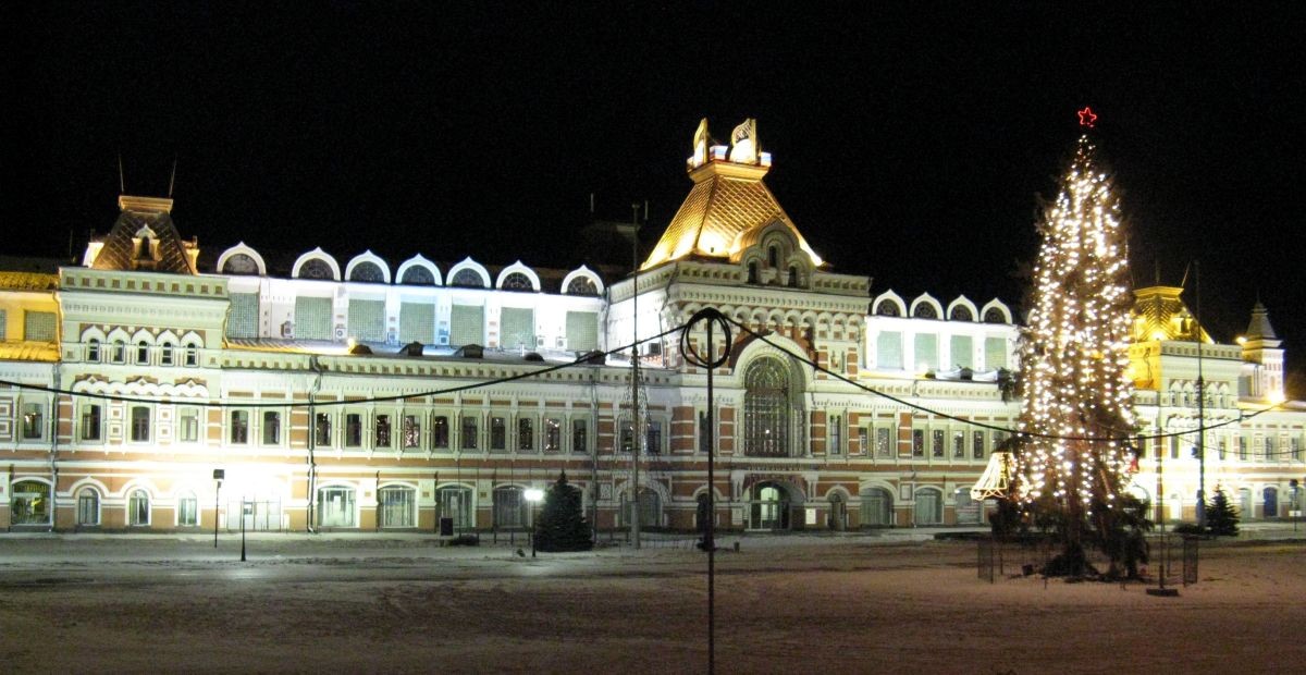
Nizhny Novgorod Yarmarka, commonly known simply as the Yarmarka — a commercial and exhibition complex in the Kanavinsky District of Nizhny Novgorod. Official name: "Main Yarmarka Complex". Shops, banquet halls, exhibition pavilions, a fountain.
History of the yarmarka
Pre-state period
The yarmarka traces its origins to one of the oldest trade routes in the history of the peoples of Eurasia — the Volga River route. This route connected Northern Europe — the territories that would later take shape as the Hanseatic trading league — with Persia and India, before the sea route around Africa was discovered.
In the pre-state period, trade along the Volga followed the pattern typical of continental trade routes: a caravan of vessels passing through lands controlled by a particular people or tribal confederation would either pay an agreed sum (in practice, hand over a portion of its goods) in exchange for that people "guaranteeing the merchants' safety," or, if it had an armed detachment, travel without such arrangements, accepting the risk of attack. In practice, the method used depended on what was more accessible to the merchants. Persian merchants carrying prized spices, luxury goods, fabrics, dried fruits, sweets, and the like had little difficulty negotiating peacefully, while caravans from resource-poor Scandinavia were often forced to resort to violence. This is perhaps why the most numerous of the Peoples of Nizhny Novgorod adopted a self-name of Iranian origin, despite their Finno-Ugric culture and Baltic roots.
Khazar period
According to medieval travellers, the first trading post in the Nizhny Novgorod lands belonged to Khazaria — Abramov Gorodok (Abraham's Settlement) — founded not far from the mouth of the Oka, probably by agreement with the local tribal chieftains. Throughout all subsequent history, the fate of these lands was most intimately bound up with Volga trade. After the fall of Khazaria — brought about by climate changes in the Volga delta and completed by the campaign of the Rurikid Svyatoslav — the center of trade shifted to the mouth of the Kama, to Bulgaria, and the Khazar trading post of Abramov Gorodok became the Bulgarian fortress of Shehr Ibrahim and the trading settlement of Ibrahim Balyk.
Russian period
At that time it was impossible to reach Nizhny Novgorod itself in a single navigation season. The act of relocating the yarmarka from Bulgaria to Makaryev reveals not only Moscow's desire to draw Volga trade closer to itself, but also the subtleties of regional policy — in seeking the swiftest possible Russification of the Erzya, the authorities could not rely on the stick alone, and the relocation of the yarmarka to Erzya lands was used by Moscow as a carrot. And yet another fire at the Makaryev Yarmarka (attributed by some to the commercial interests of Nizhny Novgorod merchants) led to its relocation to the Strelka.
As the fleet developed and navigation to Nizhny became practicable, the yarmarka moved there, where it gradually became an increasingly ceremonial affair. Despite the authorities' efforts to preserve the fair — including the All-Russian Trade and Industrial Exhibition held in Nizhny in 1896 — the yarmarka's turnover declined, and by the start of the First World War it simply closed, coinciding with the introduction of prohibition, since its commercial significance was already negligible and its cultural and recreational role (something like a Russian Las Vegas) was viewed negatively by the government against the backdrop of the "Great War."
After the world war and the civil war, during the NEP era, attempts were made to revive the yarmarka, but without success. Curiously, Stalin, through the construction of the Moscow Canal, in effect attempted to shift the center of the country's river life even further west — to Moscow — a move accompanied by the propaganda campaign proclaiming "Moscow, Port of Five Seas." The considerable population that had made its living from Volga trade was redirected by Soviet power toward servicing the military needs of the party leadership. When the program of armed isolation of sparsely populated, resource-rich lands ultimately failed, attempts were made once again to revive the yarmarka, but it soon became clear that, in a world dominated by maritime and railway transport, it had no real economic foundation.
State involvement
The yarmarka is undoubtedly the defining landmark of the Zarechka (the low-lying riverside part) of Nizhny Novgorod. In the nineteenth century it transformed what had once been a backwater riverside district into a center of trade and made our city famous not only throughout Russia but on an international scale.
After a fire on August 18, 1816, at the all-Russian yarmarka near Makaryev Monastery, the Russian government decided to relocate it to Nizhny Novgorod. Engineers I. Puadebard and A. Digo were sent to determine the site of the future market. They examined several locations and chose the Strelitsa — the confluence of the Oka and the Volga River.
Since ancient times this area had been cut through with lowlands and ravines and dotted with lakes — the largest being Barantsevo and Meschera Lake — while a long sandbar stretched toward the confluence of the rivers. The Strelitsa was considered part of the city's territory. In the 16th and 17th centuries, blacksmith shops and brick sheds belonging to local residents stood here. In the early 19th century, separate plots of land belonged to the neighboring Kunavinskaya sloboda, Voznesenskiy Pecherskiy Muzhskoy Monastery, the Assumption Church, and the noble families of the Stroganovs, Shakhovskoys, Vsevolozhskys, and others. At the very tip of the Strelitsa, three sawmills had stood since the late 18th century.
On February 1, 1817, I. Puadebard and A. Digo submitted to the government a plan for the layout of the yarmarka complex, envisioning one-story trading halls arranged in two and three rows along the Oka bank. The plan was rejected; on April 8 of the same year it was resubmitted in revised form: 26 rows of shops in two lines along the Oka bank, with Meschera Lake to be connected by a channel to the Volga so that goods from vessels could be delivered by boat directly to the shops. This plan was again rejected.
The Betancourt Plan
In the spring of 1817, the architect Agustín de Betancourt, who headed the government Committee on Construction and Hydraulic Works, traveled to Nizhny Novgorod. The preliminary design he drew up became the foundation for a large and magnificent yarmarka ensemble. Betancourt's plan (without a cost estimate) was approved by Alexander I, and detailed work on the architectural and engineering solutions began immediately.
Six million rubles were allocated for the construction of the yarmarka complex over four years. The plan included a cathedral, 3 administrative buildings, 4 Chinese trading arcades and 56 two-story rows, and 2 lines of underground sewage galleries. The entire territory was to be enclosed by the Betancourt Canal, supplied with water by the 30-kilometer Pyrsky Canal with its locks. Betancourt moved the construction site to a higher location closer to Kunavinskaya sloboda to reduce the risk of flooding, and ordered the low-lying areas to be filled with sand to a depth of 6–8 meters, which slowed construction and increased its cost. In the spring of 1818, the foundations of the yarmarka buildings were laid. By the summer of 1822, the main work was complete. On the night of July 14–15, the market was officially opened in the newly built premises.
That same year, construction was completed on the Spaso-Preobrazhenskiy Cathedral, which later became known as the Cathedral of the Transfiguration of the Savior. The cathedral was designed by A. A. Betancourt, while its facades were developed by Auguste R. Montferrand — hence the striking resemblance between this Nizhny Novgorod church and St. Isaac's Cathedral in Saint Petersburg.
The Spaso-Preobrazhenskiy Cathedral is the only structure from the original yarmarka buildings to have survived to the present day.
Development of the yarmarka ensemble continued. By 1828, a three-story clergy house with a bell tower had been erected behind the Old Yarmarka Cathedral, and along the axis of the Chinese arcades, beyond the Betancourt Canal, an Armenian church and a mosque were built. Construction on the land adjoining the yarmarka, apart from the sandy shoals on the Strelitsa side, was categorically forbidden in order to prevent fire.
In 1857 a severe fire broke out at the yarmarka, after which Betancourt's long-standing decree prohibiting the construction of "permanent buildings" around the yarmarka was repealed. Two years later, after another fire on the yarmarka side, the territory between the Betancourt Canal and Kunavinskaya sloboda was permitted to be built up with stone private buildings.
Between 1864 and 1881, the territory of the Strelitsa was replanned. A square was laid out there, at the center of which, to a design by architect Lev Vladimirovich Dal, the new five-tent-roofed Alexander Nevsky Cathedral was erected, linking the yarmarka, the parterred confluence of the Oka and the Volga, and the right-bank part of Nizhny Novgorod into a unified urban planning system.
The Passage
In the late 19th century, the main building of the Nizhny Novgorod Yarmarka became the dominant feature of the yarmarka complex and is now a federally designated historical and architectural monument. It was erected on the site of three administrative buildings constructed in 1818–1822 according to Betancourt's plan. Those buildings had been built on filled ground, and over time uneven settling caused cracks to appear in their walls. In 1885, upon inspection of the buildings, architect E. I. Zhiber determined that they might soon collapse.
In early 1889, a special commission was formed to oversee construction of a new main yarmarka building and announced a design competition. In the spring of that year, the submitted works were put on display in the halls of the Saint Petersburg Academy of Arts. First prize went to architect K. V. Treyman, though with the requirement of revisions, which were soon made with the participation of G. A. Trambitsky and A. I. von Hogen. On May 19, 1889, the joint design of the three architects was approved; the commission noted in the building's architecture a blending of styles — Old Russian and European Renaissance.
The artistic concept was built on the principle of creating, in miniature, an entire Old Russian city — complete with fortress towers, tall tent-roofed chambers with their ornate decoration (in the spirit of the 17th century) — while the interior opened into a standard commercial passage with surrounding galleries. Elements of French Renaissance decoration present in the original design were replaced with Old Russian ones: arches with hanging keystone pendants, panels with figured inset "patterned sets," and rows of kokoshnik roof gables. Although specialists describe the architects' stylistic choices as "outright stylization," the main yarmarka building was recognized as "a notable monument marking the final stage in the architectural development of the Nizhny Novgorod Yarmarka complex."
The foundations of the main yarmarka building were laid on June 22, 1889. Day-to-day supervision of the work was entrusted to the yarmarka architect N. P. Ivanov. Construction took just one year, and on June 15, 1890, the fully finished building was opened to visitors.
Nizhny Novgorod local historian Nikolay Khramtsovsky wrote of it: "The main yarmarka building is of elegant architecture. Its southern and northern facades are adorned with light porticos and pediments. Part of the upper floor is occupied during the yarmarka by the governor of the province and the commandant of the yarmarka; other parts contain a hall, a dining room, and formal drawing rooms. On the lower floor are the governor's chancellery, a club, and a restaurant. Directly beneath the center of the building, a gallery houses shops selling various luxury goods and works of art: silk fabrics (European and Asian), cosmetics and haberdashery, various accessories for ladies' and gentlemen's dress, Yekaterinburg stonework and mosaics, prints, and more. In the evenings this gallery is brightly lit with lamps; in its center, on a stage, an orchestra plays. From dusk onward a large crowd gathers in the gallery — to shop, to meet acquaintances, or to listen to music. At such times the gallery is so crowded that if one needs to pass from the north door to the south, or vice versa, one could walk around the entire building five times in less time. By around nine o'clock the gallery grows emptier, the public begins to disperse. By eleven in the evening the gallery is deserted, the music falls silent, and the lights go out."
The side wings (flanking buildings) of the main yarmarka building housed various city services. In the eastern wing, on the upper floor: the police administration with the chief of police, the justice of the peace, the housing commission, the commercial bank office, and a doctor's reception room. On the lower floor: the exchange hall, a pharmacy, and part of the fire brigade. In the southern wing, on the upper floor: the yarmarka office, its director and clerks, the postmaster, and post office officials; on the lower floor: the post office, the office for the sale of stamped paper, and the guardhouse.
The Shops and Underground Galleries
The extensive territory around the main yarmarka building — on which, during the Soviet years, Dolzhanskaya Street, Manufakturnaya, and Sovnarkomovskaya Streets, Yarmarochny Proyezd, and Mir Boulevard were laid out — was occupied by the yarmarka.
It contained, as is well known, a vast number of permanent and temporary trading halls, with the number of shops estimated at approximately 2,520.
At the northern, non-facade entrance to the main yarmarka building was a small forecourt with a garden, in which stood a confectionery popular among traders. On three sides of this forecourt were 12 rows, each containing 4 buildings (48 in total on the trading yard territory). Each building, as Khramtsovsky writes, contained "21 through-shops, or 42 units, except for the first two from the main building, which had seventeen through-shops, or 34 units. All these buildings were intersected by 14 streets, eleven of which ran from south to north and three from east to west. The width of these streets, except for the main avenue, was six sazhens. The avenue itself, running from the northern portico of the main building to the cathedral (the present-day Yarmarochny Proyezd), was 15 sazhens wide. A boulevard and four pump wells were laid out along it. In the evenings the boulevard was filled with strollers."
On the eastern and western sides, the yarmarka territory was flanked by underground sewage galleries. "To provide access to them, ten stone pavilions in the Turkish style were built on each side; throughout the yarmarka, stoves in these pavilions are fired daily to drive out dampness and foul odors," wrote Khramtsovsky. "The galleries themselves are flushed with water from the canal surrounding the yarmarka several times a day. The water carries the waste into pipes that have been laid specially to drain into the Oka. The construction of these underground works, so useful when great multitudes of people congregate, excites the admiration even of all European travelers who have seen them. It demonstrates the government's concern for public health and reflects credit on the inventive mind of their builder."
On three sides — east, west, and north — the vast yarmarka territory was encircled by the famous Betancourt Canal. It ran along what is now the boundary of the Mescherskiy Microdistrict, near the present-day Kerchenskaya and Sovetskaya Streets. The banks of the canal were connected by ten bridges: four for vehicle traffic and six for pedestrians. Water was channeled into the canal from Meschera Lake, which, as today, lay to the northeast of the yarmarka.
Originally Betancourt had planned the canal so that vessels could travel along it from the Oka directly to the yarmarka. This proved impractical, and was later deemed impossible, since the level of the Oka is much lower than that of Meschera Lake. So the canal's purpose was reduced, according to Khramtsovsky, to "flushing the underground galleries and supplying water for various needs — but not for drinking, as that water is not very good. From this same canal, water was piped to the pump wells installed on the main yarmarka avenue."
When, in 1889–1890, an enormous main building replaced the three original administrative structures, this substantially changed the urban planning situation. The decision was then made to fill in the underground sewage galleries, and later, in 1895–1896, the Betancourt Canal, which had lost its purpose, was filled in as well.
From the Bridge to the Strelka
In the vicinity of the present-day Cape Strelka, brisk yarmarka trade was conducted in temporary wooden premises, most of which were built anew each year and dismantled immediately after the yarmarka closed. These premises were connected to the pontoon bridge across the Oka, whose character changed sharply in accordance with the demands of trade. In the part of the bridge that rested on posts over the sandy Oka bank, there were a labor exchange for day laborers, taverns, so-called reference points for traders, a Cossack guardhouse, money-changing tables, and small stalls of watchmakers. Closer to the yarmarka itself, on specially constructed terraces on both sides of the bridge, behind the railings and directly over the water, as Khramtsovsky wrote, "shops were set up in a suspended position, selling peaked caps, hats, books, Pavlovo steel goods, fur hats, old and new samovars, various small wares, and that sort of dry goods which traders call artisanal. Kvass, kalachi (bread rolls), apples, and other items were sold here as well." On the yarmarka side, the bridge ended with two taverns.
To the left of the bridge, on the sands where ramps had been built down, there were also various trading rows, taverns, cookshops, drinking houses, inns, and blacksmiths' shops. This trade-filled territory stretched up along the Oka to the next bridge, nearly reaching the then-boundary with Kunavinskaya sloboda. From the pontoon bridge connecting Nizhny Novgorod with the yarmarka, an avenue ran straight ahead, while to the left ran the straight Alexander Nevsky Street. On the right side of the avenue were eight refreshment buildings, fairground booths, and taverns, and closer to Meschera Lake — trading bathhouses, from which a cobblestone road led to the Siberian pier on the Volga, two kilometers from the yarmarka's center.
The Imperial Balance Sheet
From the mid-19th century the yarmarka flourished.
It proved to be a dynamic, constantly evolving organism that exerted influence on the state of all trade in Russia. The yarmarka had developed into a major commercial state enterprise fully meeting the requirements of urban life of the time. By this point a unique architectural ensemble had taken shape, one without equal not only in Russian but in European urban planning of the 19th century.
In the 1850s, important urban planning works were carried out: the road network was improved, and regular building lines were established along the embankments of the ring canal and the Oka. Particular attention was paid to the Oka embankment, along which Moscow Highway was laid.
The Soviet Period
In the 1920s and 1930s, the yarmarka buildings were largely converted into residential quarters, and before long a slum district had formed here — one that, for the most part, remains so to this day.
The numerous religious structures, with the exception of two cathedrals, were demolished.
In the 1940s and 1950s, the yarmarka effectively became a stone quarry for the city's new residential construction, while the passage building served as an administrative office. In the 1970s it was renovated and converted into a Detsky Mir (children's department store). On the site of the trading yard and the Betancourt Canal, multi-story apartment buildings were erected.
From the 1970s onward, the area around the passage has been subject to large-scale redevelopment in connection with plans to shift the city center from the historic part of the city to the left bank of the Oka. As a result, the architectural ensemble of the yarmarka has lost its spatial coherence entirely.
Surviving Structures
Some of the structures that supported the yarmarka's operations have survived to the present day on Strelka Street. Building No. 19, constructed in 1895, once housed the yarmarka fire station. The building at what is now No. 21B, erected in the early 20th century, served as the yarmarka water intake station.
In earlier times, the many hotels and inns on the present-day Strelka territory were home to merchants who came to trade at the yarmarka. Among the surviving buildings is the Nikitin merchants' hotel (No. 13, built in the 1880s). An interesting detail emerges when one compares the current appearance of the buildings on the Strelka with their pre-revolutionary look as preserved in photographs: almost all the buildings have lost their ground floors — they "disappeared" as the area was filled in with soil and asphalted over. And the building of the former school, next to the former tenement house now occupied by the traffic police (GIBDD), turned out to be significantly lower than the Kanavinsky Bridge.
Claims Against Former Partners
On April 20, 2017, the Arbitration Court of Nizhny Novgorod Region received statements of claim filed by JSC All-Russian "Nizhny Novgorod Yarmarka" against ten companies.
Defendants in the Yarmarka's Claims
- JSC "Drobmash"
- Association of Farmers and Peasant Homesteads of Tatarstan
- LLC "PTF 'Energo'"
- LLC "ALMAZY NYURBY"
Amounts Claimed for Recovery
- from 10,000 to 151,000
Total Amount of Claims
- over 500,000 rubles