
Vadskoye (Mordovskoye) Lake, Vad Lake — a karst lake located in the selo of Vad, a district center of Nizhny Novgorod Region. The surface area is 56 hectares.
The lake lies in the channel of the Vadok River (a tributary of the Pyana River), which goes underground before flowing into the lake. The lake belongs to the Volga basin. The nearest city, Arzamas, is located 30 kilometers to the southwest of the lake. A road connects the selo of Vad with Arzamas.
Like Svetlyar, it is listed among four natural sites of Nizhny Novgorod Region in the reference work "Notable Natural Landscapes of the USSR and Their Protection," where it is classified as a lake with a unique hydrological and hydrochemical regime or unusual origin.
Nature of the Phenomenon
The origin of Vad Lake, unlike that of Lake Svetloyar, holds no mystery: it formed as a result of the merging of several karst sinkholes in the channel of the Vadok River, Vadok — a left tributary of the Pyana.
The lake's uniqueness lies in something else entirely — its unusual hydrological regime. From the bottom, out of deep karst sinkholes — pits, or Voklina — powerful jets of cold, clear groundwater surge upward, creating concentric rings spreading across the surface above each voclina. These powerful ascending karst springs play a major role in feeding the lake.
In some years, the water above the voclinas does not freeze — such is the pressure of the groundwater.
When the water level in Vadskoe rises, the water level in the nearest lakes and voclinas rises simultaneously, confirming the theory that the karst cavities are interconnected.
The lake's double name — Vadskoye or Mordovskoye — stems from the fact that in the 19th century the village of Mordovskaya stood on the northern shore, while the settlement of Vad lay on the southern shore. Today the two settlements have merged and bear the name "Vad," derived from the Mordva word "vad'" — water.
Current State of the Lake
The lake is fed by powerful ascending karst springs; from the central voclina a jet of water surges intensively. In the 19th century there were two springs, but by the beginning of the 21st century only one remained — the second outlet had closed. In winter the water above the voclinas does not freeze. The strong pressure of the underground water jet creates the impression of a convex lens above the lake's surface. The intense current extends 15–20 metres from the voclina, and the boundary between the clear water from the karst funnel and the slightly turbid water of the lake — carrying plant debris — is clearly visible. For this reason, water transparency ranges from 1.5–2 metres at the lake's surface to 50 metres inside the cave.
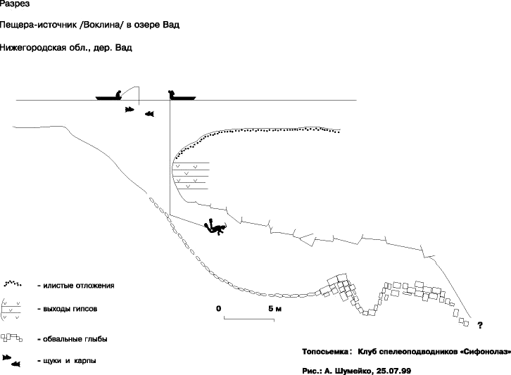
The vaults of the underwater cave gradually collapsed: as recently as 2003, the depth in the cave's main chamber was 24 metres; by 2005 it was only 20.5 metres. The maximum depth of the cave in late 2006 to early 2007 was 22.7 m, with the deepest point located in the right section, in a vertical fissure (see fig.).
In the first days of April 2007, the entrance to the voclina collapsed — and possibly the entire cave with it [14][15]. After the collapse, a bowl 7 m deep was formed. The cave may have survived in some form, but the entrance could not be found: water forces its way through the bottom, and the currents stir up a heavy silty turbidity. Shortly after the collapse, a second voclina — buried under various debris during the previous century — began to reopen.
History of the Question
The lake is mentioned at the end of the 18th century by the first researchers of the Nizhny Novgorod Region's natural history: it was observed by I. I. Lepyokhin (1771), P. S. Pallas (1768) [6], and I. G. Georgi (1775). As a phenomenon of Nizhny Novgorod landscapes, it is described in detail in the works of the Dokuchaev expedition "Materials for the Assessment of the Lands of the Nizhny Novgorod Governorate": "…имѣетъ на днѣ двѣ ямы, изъ которыхъ бьютъ струи прозрачной воды…" ("Materials for the Assessment of the Lands of the Nizhny Novgorod Governorate," issue V, p. 15).
The lake is somewhat elongated from west to east along the course of the Vadok; depths do not exceed 3 m, but in the areas of the voclinas they reach 12–15 m.
The water is clear, of sulfate-calcium composition. The northern and southern shoreline slopes are fairly high and in places steep, while the banks themselves are low. The area surrounding the lake is pitted with karst funnels and sinkholes — both fresh and overgrown, dry and water-filled. One of the most recent funnels on the northern shore, situated on the edge of the village, takes the form of a small lake of regular circular shape, 20 m in diameter. Its banks are beginning to be overgrown with sphagnum moss mats. On the southern shore of the lake, the stream Vatyma flows into the Vadok. The Vadok is a peculiar so-called "diving" stream: before reaching the lake it loses its waters into sinkholes and funnels and becomes a narrow trickle with an intermittent flow, only to become full-flowing again below the lake. It has been observed that when the Vadskoye lake is dammed, the water level in the neighboring small karst lakes and funnels rises. This allows one to speak with confidence of a network of underground channels and passages in the area of the lake.
Unfortunately, the lake's original appearance has been greatly altered by the construction of dams. In 1938, the former monastic earthen dam was restored, and in 1967 it was replaced by a substantial structure with a paved road and reinforced-concrete gates: the plan was to create a complex of water bodies for breeding waterfowl and fish.
Vad Lake was transformed into an artificial reservoir and acquired the triangular shape typical of a pond, with the dam forming its base. Of the two vaucluses identified by V. V. Dokuchaev, only one has survived; from it one can still observe a powerful discharge of groundwater that forms a distinctive convex lens on the surface, with ripples radiating outward from the center. To an observer examining the vaucluse from a boat, the sight is utterly fantastic: through the transparent water, a large funnel is visible on the bottom in the limestone bedrock. Its walls are strikingly mosaic-like, colored in shades of blue, white, green, and gray. This palette is created by clusters of green and blue-green algae, deposits of silt, and the limestone showing through them. The vaucluse's colorful adornment is completed by plants rising to the water's surface — curly pondweed and whorled water-milfoil, with pink stems over 2 m long and pinkish-dark-green leaves.
The funnel is up to 15 m deep, 20 m wide, and 27 m long. At the base of its northeastern wall, which slopes at up to 60°, an opening approximately 3 m in diameter is visible, from which the upwelling stream of water emerges.
Divers from the Moscow Aviation Institute, during their survey of the vaucluse, discovered that this opening leads into a karst cave-grotto. The remaining walls of the funnel slope at no more than 20°. The water in the funnel is cold: even on a hot summer day, its temperature 10 cm below the surface does not exceed 5–6°C.
A geobotanical study of the lake, conducted by GU student G. A. Kondrashkina, showed that it belongs to the category of heavily overgrown water bodies (80 percent overgrown).
The coastal thickets are dominated by common reed, while the open water is home to communities of duckweed, hornwort, mare's-tail, and stonewort algae. The lake is also of great scientific value as a botanical site: rare aquatic and riparian plants grow here — Zannichellia palustris, thread-leaved crowfoot, Tabernaemontanus bulrush, and Alisma loeselii, which within the Region is otherwise found only in Lake Yembasovsky.
In the past, Vad Lake was renowned for its rich fish stocks. It serves recreational purposes and has water-conservation significance. Yet Vad Lake has had a difficult fate.
Vad Lake during the Soviet period
In 1985, a fish-farming sovkhoz (state farm) called "Vadsky" was established here; its ponds were laid out below the dam. In accordance with the standards of this enterprise, the lake water is drained in winter for sanitary purposes to allow the lake bed to freeze through. That same year, the local kolkhoz (collective farm) "Rodina" began extracting bottom sediments from Vad Lake: sapropel was dredged by a suction dredge, and on the southern shoreline slope the Collective Farm "Krasnaya Strelka" set up a summer livestock encampment, after which streams of manure began flowing into the water with rainfall and snowmelt.
The lake's shores and waters are heavily polluted by household waste. Karst sinkholes on the northern shoreline slope have been turned into a district landfill. In the forest above the lake, through which the Vadok flows, the water-protection zone is not observed: trees are felled right down to the riverbank, the turf cover around it has been torn up by heavy machinery, and the riverbed is cluttered with fallen tree trunks. At the point where the Vadok enters the lake, its channel has been driven over and compacted by a road laid across it. To avoid a detour along the paved road, the Collective Farm "Krasnaya Strelka" piles up an earthen dam here every year, which is swept into the lake during the spring flood and with rainwater.
Through a narrow pipe under the road, a barely perceptible trickle of water forces its way. The Vadok River is heavily polluted by the Lomovsky distillery (Arzamassky District), which discharges untreated effluent into it. This mode of exploitation does not support the lake's existence as an integral ecosystem; rather, it leads to the outright destruction of this priceless creation of nature on the Russian Plain. The drive for short-term gain and the ecologically unsound use of the lake will inevitably ruin its hydrological regime (the sole voklina will silt up), the water body will become shallow, overgrow, become enriched with organic matter, become polluted, and rare plant species will of course disappear. In 1988, the district branch of the All-Russian Society for Nature Conservation succeeded in halting the barbaric extraction of sapropel.
Flora of the Lake
Today, Vad Lake can be characterized as heavily overgrown. The basis of its flora (according to research by G. A. Kondrashkina) consists of:
- common reed — in the lakeside thickets,
- water milfoil,
- hornwort,
- water horsetail,
- charophyte algae;
including rare species:
- Zannichellia palustris,
- thread-leaved water-crowfoot,
- Reed of Tabernemontana,
- Alisma loeselii.
Fauna of the Lake
In the late 19th century, according to N. Varpakhovsky, the lake was inhabited by:
- roach
- ide
- tench
- stone loach
The researcher was struck by the fact that, despite the mixing of riverine and lacustrine fish species, Vad lacked crucian carp, perch, ruffe, and pike.
At present, the following species inhabit Vad Lake:
- carp
- crucian carp
- bleak
- perch
- pike
- roach
- silver carp
- grass carp
The great crested grebe nests on the lake — Vad is one of three lakes where this bird is protected together with its habitat — as do the black-necked grebe, swans, and the white-winged tern.
Recreation
Vad Lake was very popular among diving and freediving enthusiasts, who made dives into the voklina and the adjacent grotto. The lake is also quite popular among anglers and spearfishers. In 2005, a hotel and dive center called "Vadskoy" opened on the lake's shore.